Visit Worldwide Topsites
Showing posts with label Craters-Guericke and Parry. Show all posts

Sunday, 12 October 2014

Fra Mauro and Parry lunar craters seen by astronomical telescope.


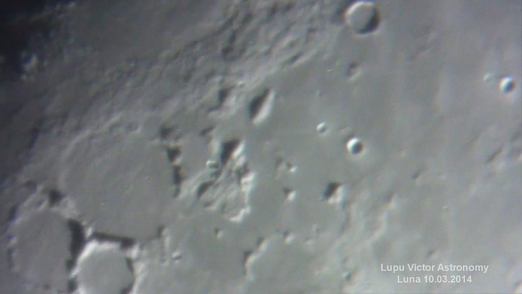
Fra Mauro (95 km) is a flooded crater with low edges, which makes it difficult to see even through an astronomical telescope, although it has 95 km, but in these lighting conditions with the sun at a low angle, it comes easier revealed.

South of Fra Mauro crater there are other two: Bonpland (60 km) and Parry (48 km), similar to each other and also flooded.

Rimae Parry, a straight trench, starts on the floor of Parry to the west, and reaches the crater Fra Mauro, cutting it in two.

Apollo 14 landed in the Fra Mauro. The crew was formed by Alan Shepard and Edgar Mitchell, and they collected there rocks called breccia, composed of broken fragments of minerals cemented together. These rocks were deposited there by the impact that formed Mare Imbrium, partially covering the crater. This blanket of rocks is known as the "Fra Mauro formation."

Fra Mauro name of this crater is given from the cartographer Fra Mauro, who did not made maps of the Moon but the Earth. He died in 1460 and was a monk after mid-life in the St. Mihail monastery of Venetian Republic.

Moon Age: 9.05 days
Phase: 70.5% (0% = New, 100% = Full)
Distance: 399.221 km


Optics: Celestron C8-Newtonian telescope, 20mm Plossl, 2x barlow
Mount: CG5 (EQ5)
Camera: Sony CX130
Filter: no
Date: 10/03/2014
Location: Baia Mare, Romania
Processing: FastStone Image Viewer


Thursday, 4 September 2014

Mare Nubium and flooded craters. Guericke Davy and Opelt.


What we see in these pictures are mostly craters that were flooded with lava, and only their rim survived. They are located on a stretched plateau called Mare Nubium. Of those listed are Guericke, Parry (48 km), Opelt and Davy (35 km). It retains the look circular, but with some breaks or loops.

For example, Guericke (58 km), situated on the northern Mare Nubium, shows two walls of interruptions: one to the north, which contains a lane, and one to the east. Images are upside down, as shown through telescope and cardinal points described in this article do not take into account this.
 

Guericke's west, is a small crater that would not be so obviously, if it was not placed isolated on Mare Nubium and so therefore was given to it a separate name. This is called Kundt (11 km).

An interesting crater is observed only in the first image, a crater with the eastern edge almost completely flooded (top right photo). This is Opelt (49 km) and the "mountain" chain below that normally is at it's north, is Rimae Opelt.


Moon Age: 9.05 days
Phase: 70.5% (0% = New, 100% = Full)
Distance: 399.221 km


Optics: Celestron C8-Newtonian telescope, 20mm Plossl, 2x barlow
Mount: CG5 (EQ5)
Camera: Sony CX130
Filter: no
Date: 10/03/2014
Location: Baia Mare, Romania
Processing: FastStone Image Viewer


Saturday, 23 July 2011

Guericke Parry craters and Mare Nubium


Photographer: Victor Lupu
Optics: Celestron C8-Newtonian telescope, plossl 20mm, 2x Barlow
Mount: CG5 (EQ5)
Device: Sony CX105
Filter: No
Date: 11/05/2011
Location: Baia Mare, Romania
Processing: video captures


         Guericke (58 km), is the remnant of a lunar crater on the northern Mare Nubium. To the northwest is Fra Mauro formation, with Bonpland and Parry craters. To the east are craters Kundt  (11 km) and Davy (35 km).
Guericke's surviving edge was damaged and partially submerged in basalt lava covering the floor. The wall is now little more than some circular increases. The remnant flooded crater  Guericke F (21 km) is attached outside, to the southwest.
Crater name is given from Otto von Guericke (20 November 1602-11 May 1686), which was a german scientist, politician and inventor.


        Parry crater (48 km), have about the same features,being flooded with lava. The crater name is not written in the photo below because I forgot, but is north of Guericke and you can see only the light  edges, the bottom of the crater being in dark.Name of the crater comes from Sir William Edward Parry (19 December 1790-8 July 1855), which was an English admiral and Arctic explorer, and who in 1827 tried one of the first expedition to the North Pole.

        Mare Nubium ("sea of clouds") -715 km diameter ,it is located in Nubium Basin,on the southeast of Oceanus Procellarum. The basin is considered to be pre-Nectarian, the material around the mare being from lower Imbrian era and the basin material,from upper Imbrian era. First images ever made ​​by Lunar Reconnaissance Orbiter was from Mare Nubium.
Other craters in these photos are : Arzachel,Alphonsus,Alpetragius,Thebit,Davy (35 km),Lassel (23 km),but also Rupes Recta and Rima Birt.


All images are © Copyright 2010-2015 Lupu Victor. All rights reserved.Images may not be reproduced, published, or copied in any form without written permission of the author. Thank you for respecting the intellectual property rights. ASTROFOTOGRAFIA | Lupu Victor Astronomy - Contact - About
Design by Free WordPress Themes | Bloggerized by Lasantha - Premium Blogger Themes | Online Project management